

What are the different types of clouds?
According to the International Cloud Atlas of the World’s Meteorological Organisation, there are over 100 different types of clouds in existence. However, each one can be divided to become part of ten basic types of clouds, depending on its height and general shape in the sky.
Are you interested in cloud watching or just curious to know what clouds are overhead? Read on to discover how you can recognize different clouds and what type of weather each one would bring.
Types of clouds:
-
Cumulus Clouds

Source: Pxhere
Remembered the type of cloud you learned to draw at an early age? If you do, they are cumulus clouds, and they serve as the symbol of all clouds, even as snowflakes symbolizes winter. They are usually round and puffy at the top and very bright during sunlight. They are relatively flat and dark at the bottom.
Cumulus clouds are indicators of fair weather. However, they could become a thunderstorm if they grow tall.
-
Cirrus Clouds
Cirrus clouds are high and feathery. Scientists believe they are made of ice particles because of their distant height. Whenever you see these clouds scattered across a clear blue sky, know there would be fair weather.
-
Stratus Clouds
Stratus is the flat, uniform layer of greyish clouds that hang low in the sky. It shares similar characteristics with fog that hug the horizon, instead of the ground. When you see these clouds, know there is going to be a drizzle or overcast rain.
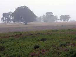
Source: Jim Champion via Wikimedia Commons
-
Stratocumulus Clouds
Stratocumulus refers to low, puffy, whitish or greyish clouds that usually forms in patches with blue sky visible in-between. When you view them from beneath, you will discover they have a dark, honeycomb appearance. Stratocumulus mostly appears on cloudy days, especially when there is a weak convection in the atmosphere.
-
Nimbostratus Clouds
These clouds will typically cover the sky with an extensive dark grey layer. Nimbostratus clouds are thick and can quickly blot out the sun. It is the cloud that you will see whenever snow or steady rain is falling or is bound to fall.
-
Cumulonimbus Clouds
These clouds grow out of cumulus clouds. Their bulging upper portions resemble cauliflowers. Cumulonimbus clouds have plume-flat tops with a dark and hazy bottom. When you see this cloud, know there is a threat of a thunderstorm—a short but torrential downpour, even tornadoes or hail.
-
Cirrostratus Clouds
Cirrostratus is a whitish, transparent cloud which covers almost the entire sky. You can easily picture this type of cloud by a circle of light or ring around the sun or moon. Cirrostratus is an indication that a significant amount of moisture is present in the upper layer of the atmosphere—meaning possible rain.
-
Altostratus Clouds
Altostratus is clouds that wholly or partially cover the sky at mid-day levels, but also allow you to see the sun. They are usually bluish grey or merely a grey sheet of clouds. It indicates a warm or occluded front.

Source: Pxhere
-
Altocumulus Clouds
Altocumulus clouds are the most typical or ordinary clouds visible in the sky. You can quickly identify them by their grey or whitish patches that dot the most parts of the sky in round masses or min parallel band alignment. They usually look like a bunch of sheep. Usually, are spotted on humid and warm mornings during the summer. Also, they can also signify up-coming thunderstorms.
-
Cirrocumulus Clouds
Cirrocumulus refers to tiny, white patches of clouds that appear at high altitudes. They are mostly arranged in rows and are made of crystals. They are sometimes called ‘cloudlets’ or ‘mackerel sky’ and look like grains. Cirrocumulus clouds are scarce and are usually short-lived.
Conclusion
Clouds are fascinating to watch and if you want to become an expert in a weather forecast, study more about clouds, and you will be glad you did. Here is a key to the parts of the whole word.
Cirro-High level Alto- Mid-level Cumulo- Vertically Developing Nimbo or Nimbus- Heavy precipitation Strato- Stratosphere
Cirrus- wispy and thin Cumulus- puffy and round Stratus- flat and grey
Image Resource: Featured Image Source https://en.wikipedia.org/wiki/List_of_cloud_types#/media/File:Cloud_types.jpg, https://commons.wikimedia.org/wiki/File:Backley_Holmes_in_the_drizzle,_New_Forest_-_geograph.org.uk_-_231372.jpg