
![Chart of abnormal Pacific ocean surface temperatures [ºC] observed during the El Niño in January 1983.](https://www.weatheregg.com/wp-content/uploads/2019/04/320px-El_Niño_1982-83-1.png)
The National Oceanic and Atmospheric Administration (NOAA) announced on the 14th February 2019 that El Niño is here officially.
In a press release, the climate agency stated that: “El Niño conditions have come together across the Equatorial Pacific, and we can now announce its arrival,” said Mike Halpert, deputy director, NOAA’s Climate Prediction Center, and forecaster ENSO. “While sea surface temperatures are above average, current observations and climate models indicate that this El Nino will be weak, meaning that we do not expect major global impacts throughout the rest of the winter and into the spring.”
Well, it’s official. El Niño is upon us. So, what’s El Niño?
Events in El Niño are just one-half, the warm, wet half, of a naturally occurring weather cycle called the “El Niño Southern Oscillation,” or ENSO.
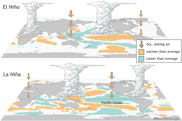
During an El Niño event, the tropical Pacific Ocean surface becomes warmer than usual, especially in the equator and along South and Central America’s coasts. Warm oceans lead to low-pressure systems in the above atmosphere, which in turn leads to plenty of rain for the Americas ‘ western coasts.
The deluges had been so strong during most of the notable El Niños of the past that whole villages slipped down the hillsides. Ocean temperatures skyrocketed off the Peruvian coast during the 1972-1973 event, almost wiping out the country’s critical anchoveta fishing industry. The country sustained more than $3.5 billion in damage to buildings, agricultural land, and other infrastructure during El Niño from 1997 to 1998. Corals bleached across the Pacific in 2016, South America was ravaged by floods, and fires fuelled by drought ripped across Australia.
The events can last as long as a year, though, during the fall and winter months of the Northern Hemisphere — October through February; the warming tends to be strongest. Indeed, this timing is the source of the name: “El Niño” in Spanish means “male child,” and it also refers to the Jesus baby. South American fishermen, who knew and described the phenomenon for a long time, called it “El Niño” because some of the biggest effects spin around Christmas — and the name stuck.
What about La Niña?
Another half of the ENSO phenomenon is referred to as “La Niña.” It is the opposite of an El Niño; ocean temperatures cool down along the eastern half of the tropical Pacific, and that part of the world dries out. The heat and rain band is swinging to the other side of the ocean, making Australia, Indonesia, and Southeast Asia weather and warmer than usual.
La Niña Events usually settle in longer than El Niños, lingering between nine months to two years somewhere. Almost every two to seven years El Niños and La Niñas usually occur. Ocean temperatures and patterns of rainfall become more average in the meantime. However, the patterns are not perfectly clear— a strong El Niño does not necessarily mean that the following La Niña is going to be particularly intense, and vice versa.
Why do El Niños happen?

This image shows the difference from average sea surface temperatures at the Equator in the tropical Pacific during January 2019, as compared with the period from 1981-2010. On February 14, 2019, NOAA announced that El Nino has arrived, but it’s likely to be weak with little influence on weather through early Spring 2019.
The trade winds at the beginning of an El Niño, which usually whisk briskly across the tropical Pacific slackening surface. These winds usually push warm ocean surface waters eastward to Asia and Australia, where Australia to the south, the Indonesian archipelago near the equator, and Southeast Asia essentially corralled into a giant warm pool.
In a typical year, as the trading winds push waters eastward from the sun-warm surface, away from the cliff of Central and South America, they draw cold water from deep below, “upwelling” the cold, nutrient-rich seas.
Related Article:Some Tidbits About El NiñoUsually, trade winds also induce the upwelling of deep, cold waters near the equator. It’s cool and not too rainy along the west coast of the Americas during a normal year, and warm and wet in the west part of the Pacific.
But once the trade winds die, two things do happen; the wind-forced upwelling that pulls cool water to the surface is slowing down, and the warm water that has pooled up in the western part of the Pacific Basin is beginning to slide back east.
And as the warmth spreads eastward, the trading winds–partly controlled by the differences in temperature and air pressure between the Pacific’s two sides–get even weaker. So there’s a double whammy: the cold waters that usually help cool down the South American coast stay deep under the surface, and the winds that help cool things stagnate down.
And there you have it…El Niño
About the Author:
This blog was written by Linda Rawson, who is the founder of DynaGrace Enterprises (dynagrace.com) and the inventor of WeatherEgg (weatheregg.com). For further information, please connect with Linda on LinkedIn, or contact her at (800) 676-0058 ext 101.
To help kids with Weather Linda has created coloring books in four different languages. WeatherEgg Kids: Weather from A-Z: Coloring Book (https://amzn.to/2HMhOgp), WeatherEgg Kids: Palabras del clima: Libro de colorear (https://amzn.to/2I2c7KK), WeatherEgg Kids: Wetter Worte: Malbuch (https://amzn.to/2YFuf31), and WeatherEgg Kids: Les mots de la meteo: Livre de coloriage (https://amzn.to/2HZGAcd)