

When a tropical cyclone hits, many people experience the wrath of the most violent type of storm on Earth. Many people refer to these storms using different names such as typhoons, cyclones, tropical storms, or hurricanes. However, what most people don’t know is that the naming depends on where the storm forms, but all types fall under the classification of a tropical cyclone. For example, to be classified as a “hurricane,” the storm form over the Atlantic Ocean or the eastern Pacific Ocean. Regardless of what people call them, all of these storms have the same underlying forces that allow them to form.
How Tropical Cyclones Form

Heat, Water, and Pressure
Warm sea water fuels tropical cyclones, so it’s no surprise that they mainly form near the equator. They can only form in regions where the ocean is at least 80 degrees Fahrenheit for approximately 50 meters deep. Warmer waters give cyclones an extra boost, so they are bigger and have a stronger storm surge. When the moist air over the ocean heats up, it rises higher into the atmosphere until there is a less air near the ocean surface. This phenomenon creates a pressure gradient where there is increased air pressure higher in the atmosphere and decreased pressure near the surface of the ocean. New air moves into the area of low pressure and gradually heats up and rises high in the atmosphere. As this air rises, new air swirls in to take its place.
Once the warm air high in the atmosphere cools off, the high water content in the air causes clouds to form. The water droplets in the air condense, which forms cumulonimbus clouds. This system is repeated many times until it grows into a large system of storm clouds and fast, swirling winds.
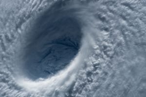
Eye of the Storm
As the winds rotate faster, the eye of the storm forms in the center. Inside the eye, it is very calm. The eye remains clear of the storm because it has extremely low air pressure, and the high pressure from above flows down into it. Since ocean’s heat and water evaporation fuels the storm, the cyclone slows down as it reaches land. However, they often move far inland before they completely die out, which allows it to dump colossal amounts of rain on any area it goes over.
Additionally, the Earth’s rotation plays a role in cyclone formation. Storms that form south of the equator spin clockwise and those that form north of the equator spin counterclockwise.
Types of Tropical Cyclones
Tropical cyclones are categorized primarily on their wind speed and total formation. Meteorologists developed a classification system that organizes tropical cyclones into four stages:
- Tropical Disturbance: A cluster of thunderstorm clouds
- Tropical Depression: Winds reach 25-38 mph
- Tropical storm: Winds reach 39 mph. This category is also when the storm gets an official name.
- Tropical cyclone: Winds reach 74 mph, the storm is at least 125 miles in diameter, and 50,000 feet high. The eye is 5-30 miles in diameter.
Dangers of Tropical Cyclones
When a hurricane hits, it releases a lot of rain, and that rain can accumulate in rivers and cause flash flooding. This flooding can close roads and completely demolish homes and buildings. Furthermore, the immense winds that come with a hurricane are strong enough to blow trees over and knock power out for as much as a month. Additionally, the amount of energy exhausted by a cyclone is immense. Raging winds can produce an electrical generating capacity equivalent that exceeds that of the entire world. However, when the winds are coupled with rain, the storm can release up to 400 thousand times the electrical generating capacity of the entire world.
The Government Monitors Tropical Cyclones

Satellite View of Cyclone by NASA’s Aqua/MODIS satellite via Wikimedia
The government has two GOES satellites that orbit the earth 22,300 miles above us. Their sole purpose is to monitor incoming tropical cyclones so the government can warn the public. NASA originally built the satellites, but they are solely operated by the National Oceanic and Atmospheric Administration (NOAA). In total, these satellites have helped save countless lives because they allow us to predict the severity of a storm as well as when and where it will hit. For example, in the most recent hurricane, Hurricane Florence, more than 1 million people are under evacuation orders and over 10 million people are in storm warning areas.
If you would like to learn more awesome weather information, visit our website weatheregg.com.
Resources: https://spaceplace.nasa.gov/hurricanes/en/, https://scijinks.gov/hurricane/, https://oceanservice.noaa.gov/facts/how-hurricanes-form.html, https://www.vox.com/science-and-health/2016/10/6/13191010/how-hurricanes-form-tropical-storms-guide
Picture Resources: https://pixabay.com/en/hurricane-earth-satellite-tracking-92968/, https://pixabay.com/en/typhoon-eye-close-up-maysak-1650677/, https://www.mediawiki.org/wiki/File:Low_pressure_system_over_Iceland.jpg, https://www.mediawiki.org/wiki/File:Hurricane_profile_graphic.gif
Great goods from you, man. I have take note your stuff previous to and you are simply too fantastic. I actually like what you have received here, certainly like what you’re saying and the best way in which you say it. You make it entertaining and you still take care of to stay it sensible. I cant wait to learn far more from you. This is actually a terrific site.